Illustration – Waterfront Development Corporation.
Community-driven collaborations have helped make people’s lives better through park access and health equity in L.A. over the past 17 years. The recent National Academies of Sciences, Engineering, and Medicine report on Communities in Action: Pathways to Health Equity recommends community-driven best practices. The report recognizes park access and residential segregation as social determinants of health, and recommends civil rights and environmental justice strategies to promote health equity. That’s the good news.
Since its inception in 1986, the Waterfront Development Corporation (WDC) has used public input and collaboration as a valuable tool in the planning and development of Louisville Waterfront Park. The entire project began with a series of public forums held in different locations throughout the community, and the public dialogue resulted in an 85-acre public park that successfully connects the urban center to the river and is well-loved and well-used. The first three phases of the park, including the Big Four® Pedestrian Bridge that connects Louisville to Southern Indiana over the Ohio River, were completed in early 2013. That same year, planning began on a long-talked-about fourth phase of the park, 22 acres located on the river on the west side of the current park site.
Waterfront Park is an urban park at the northern edge of downtown Louisville, stretching east along the Ohio River for about a mile and a half and connecting to a new residential/marina development sparked by the park. River Road marks the southern edge of the park; it continues west past the park for several blocks before terminating at a parking lot at 8th Street. An interstate highway passes over the park and then hugs the river’s edge to the west, covering River Road and continuing on around the city. A simple RiverWalk rings the city from Waterfront Park along the river to the west, but long stretches of the walkway are not easily accessible from the city itself.
Just beyond the parking lot at 8th Street, a system of elevated highway entrance and exit ramps forms a visual and psychological barrier, effectively bisecting the east and west sides of the city at 9th Street. This is commonly referred to as the 9th Street divide. In 2013, community leaders began planning to help bridge that divide by developing Waterfront Park’s fourth phase.
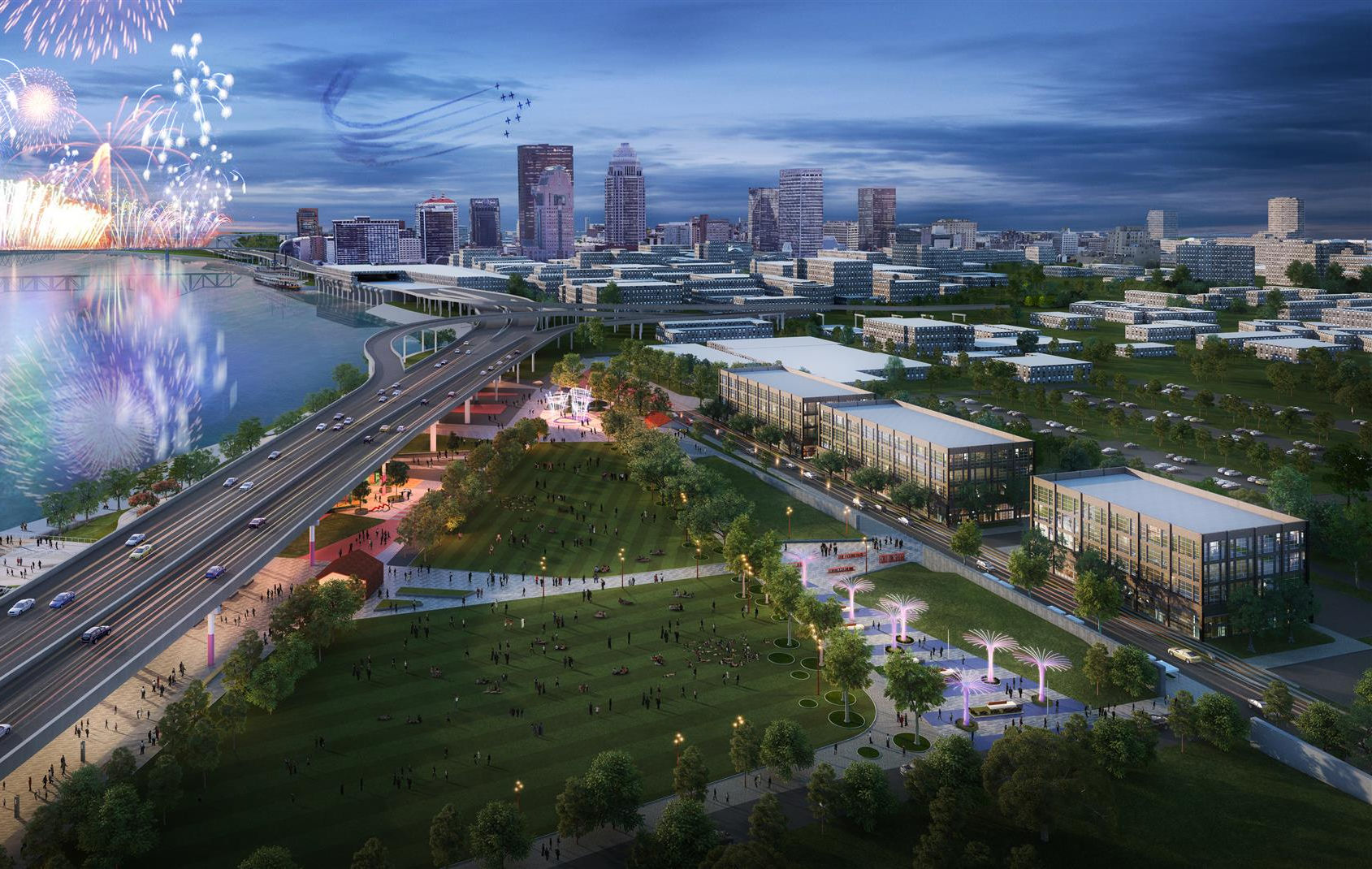
Phase IV looking east.
Photo Credit: Illustration – Waterfront Development Corporation.
…Phase IV of Waterfront Park will provide new connections between the central downtown district to Louisville’s historic Portland community with its mixture of residential and small business inhabitants.
The Phase IV site is similar to the site of the first three phases in that it is physically cut off from public access from the city side by a floodwall, and the interstate highway passes overhead near the river. It is different from the first three phases in that the Phase IV site is mostly uninhabited by structures/buildings, and there are some existing grassy and tree-canopied areas with wonderful views of the river. The RiverWalk provides a pedestrian connection from the river’s edge to the future park site. The original Waterfront Park site was made up of heavy industry and scrapyards, with no real existing neighborhood; rather, a vital neighborhood sprang up in response to the park being built. The Phase IV site is bounded to the south by an active neighborhood of businesses of all sorts. While there is room for new businesses to locate into the area, there is also a built-in population eager for the development of new park space nearby. Continuing westward, Phase IV of Waterfront Park will provide new connections between the central downtown district to Louisville’s historic Portland community with its mixture of residential and small business inhabitants.
Led by Metro Council Member Cheri Bryant Hamilton, who represents the district where Phase IV is located, a group of stakeholders – community/government leaders and business owners from the Phase IV neighborhood – came together with WDC to begin the conversation about what it would take to build Waterfront Park Phase IV. The group would focus on major issues, including how to link east to west through the 9th Street divide; connect south to north through the floodwall, and determine what park features would best serve the community while complementing but not duplicating the existing park.
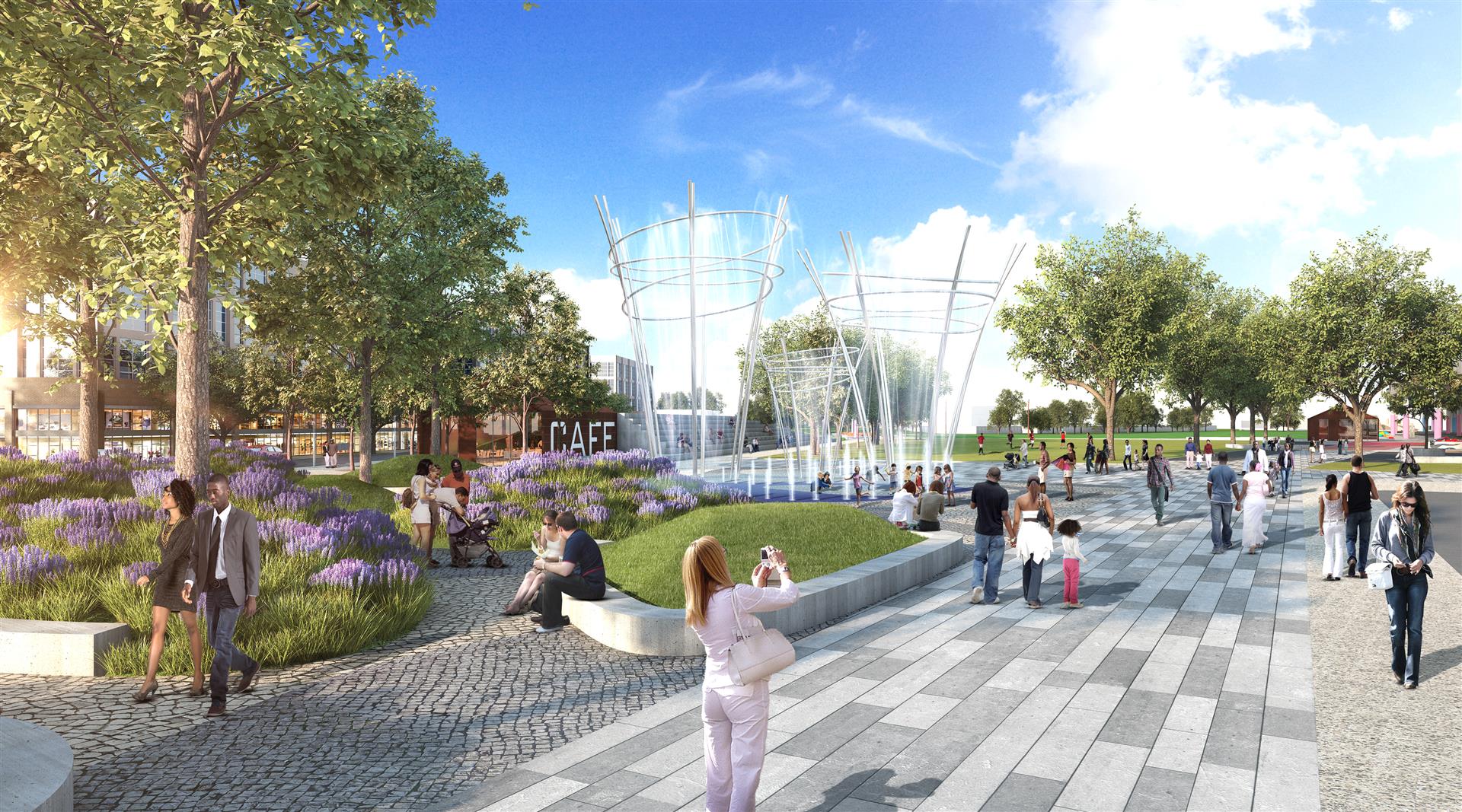
Plaza.
Photo Credit: Illustration – Waterfront Development Corporation.
The goals developed by the stakeholders included: Greenspace that transitions seamlessly between the natural riverfront and the built environment to the south and west; strong pedestrian and bicycle connectivity/circulation; festival space for civic gatherings, concerts and special events; and space for active recreation.
MKSK, an urban planning and design firm that had worked previously on projects with both WDC and the Louisville Downtown Partnership, was hired to work with the team of stakeholders to develop the master plan for Phase IV. The firm’s earlier work for the Louisville Downtown Partnership included the development of the Downtown Louisville Master Plan, completed in early 2013, which emphasized the extension of River Road westward and the development of Phase IV.
Working with the stakeholders and WDC, MKSK came up with a program that respects the rich history of the site while reflecting the needs and wants of the community.
MKSK, WDC and the Downtown Partnership determined the extension of River Road west to Rowan Street, which borders the Phase IV site to the south, would be essential to creating the connections needed for the success of the Phase IV development. The Downtown Partnership took on the management of engineering and implementing the road project.
It was also necessary to collaborate with the Louisville Metropolitan Sewer District (MSD), which needed to develop a new catch-basin tunnel in the Phase IV area. It was determined the tunnel would begin within the Phase IV site, and MSD would purchase the land needed for that expansion project, build their tunnel, and then allow that area of the park to be developed above the tunnel. By regulation, the tunnel must be completed by 2020, at which time park construction in that area could proceed.
Working with the stakeholders and WDC, MKSK came up with a program that respects the rich history of the site while reflecting the needs and wants of the community. The plan includes both passive and active venues, including:
Fort-on-Shore plaza, located at the site of a frontier fortress established by Lewis & Clark in 1778;
Foundry Commons & Gardens, which will honor the site’s former steel foundries that produced ornamental steel which was used in the Vatican, French Quarter facades, and portions of the Eiffel Tower. These areas include a large green event space and a smaller passive space with shade structures, benches, gardens, and colorful lighting;
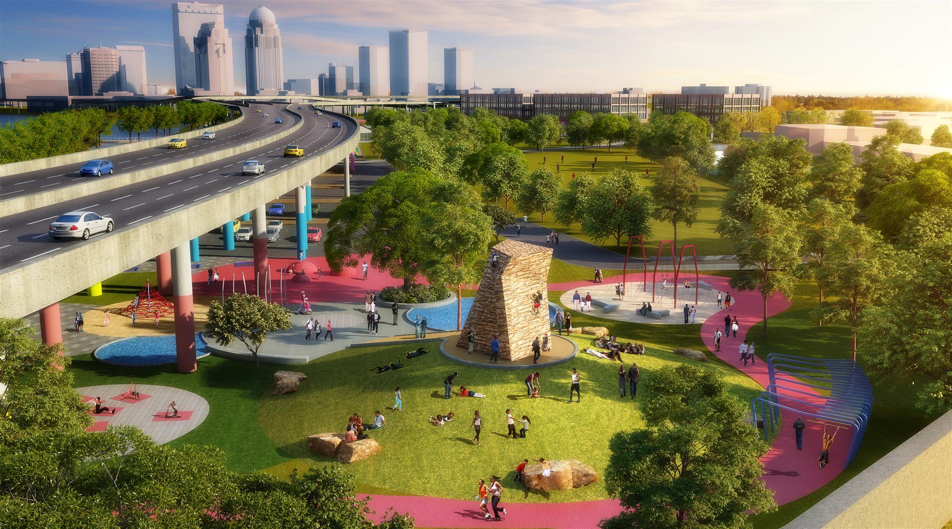
Exerscape, a concentrated area for active engagement that will include a mixture of outdoor exercise equipment and interactive landscape features; and
Waterfront Promenade, a RiverWalk experience that improves pedestrian and bicycle connections east to west and north to south.
Collaboration will be the key to ensuring all pieces of this development continue on a parallel track, resulting in an expanded outreach for Waterfront Park that complements existing offerings and serves the community well.
As planning for Phase IV continues, coordination between stakeholders, WDC, the Downtown Partnership, and MSD is crucial to the success of this project. As with the existing park, construction will be multi-phased over a number of years. Collaboration will be the key to ensuring all pieces of this development continue on a parallel track, resulting in an expanded outreach for Waterfront Park that complements existing offerings and serves the community well.
Exerscape.
Photo Credit: Illustration – Waterfront Development Corporation.
About Louisville Waterfront Development Corporation
Waterfront Development (WDC) was established in 1986. It plans, coordinates, and implements strategies to revitalize Louisville’s Waterfront. WDC was created by an interlocal agreement between Jefferson County, the City of Louisville (now Louisville Metro), and the Commonwealth of Kentucky to oversee redevelopment of Louisville’s waterfront from a blighted and underutilized area into a vibrant, active area. The result is Waterfront Park, which has improved the quality of life of Louisville residents and has also
been a catalyst for business and residential redevelopment in the Waterfront District and connecting areas of downtown Louisville.